


Box canyon...just east of Mecca...a road thru connects with Joshua National Park. I have driven in it a couple of times but never stopped to look....golly, there is a 'bunch' of great camping and hiking to be found in here.


It's a clay and sand area so if you leave the blacktop, a 4 wheel drive is pretty much mandatory.


|
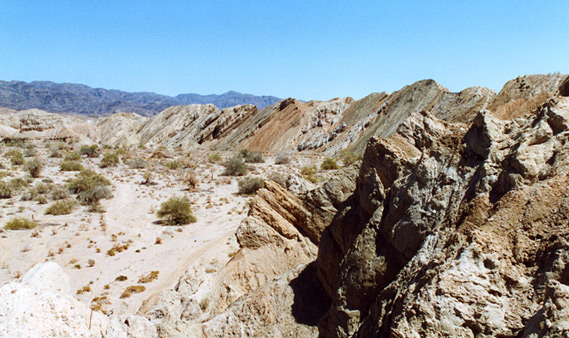
There are probably dozens of Box Canyons in California; this one is a colorful ravine through the Mecca Hills at the east end of the Coachella Valley in the southeast of the state, 40 miles from Palm Springs. The sides are formed by upturned strata - twisted, buckled and eroded, they stretch for about 8 miles along the canyon, which is part of a metamorphic zone associated with the nearby San Andreas Fault. This runs through the Coachella Valley then southeast past the Salton Sea, and affects the geology of a wide strip of land at either side. The CanyonA scenic road (CA 195) runs through the ravine, linking CA 111 with I-10 and continuing on into Joshua Tree National Park. Plant life is limited to scattered bushes and palo verde trees along the sandy floor - the jagged rock walls are completely bare. The surrounding hills contain other narrow ravines, some of which become authentic slot canyons, plus springs, oases and a large area of vividly colored badlands; one other famous location is Painted Canyon, reached by a 4 mile gravel track leading off Box Canyon road, which has impressive rock formations in shades of pink, orange and red and grey. This particular ravine leads into the heart of the Mecca Hills Wilderness Area, a 24,000 acre preserve created by the 1994 California Desert protection act. The DriveIt only takes about 15 minutes to drive through the interesting part, after which the road crosses the much more open Shavers Valley, and although there are no official trails, several days could be spent investigating the surrounding country. There are various places for camping by the roadside - good locations to stay but often with quite a lot of litter. |
|||||||||||||||||


I did a bit of Google research on the area and it is pretty serious business. Do yours before just setting out.
Orocopia Mountains
From Wikipedia, the free encyclopedia
| Orocopia Mountains | |
|---|---|

Orocopia Mountains
|
|
| Highest point | |
| Elevation | 1,117 m (3,665 ft) |
| Geography | |
| Country | United States |
| State | California |
| District | Riverside County |
| Range coordinates | 33°34′00″N 115°46′33″WCoordinates: 33°34′00″N 115°46′33″W |
| Topo map | USGS Orocopia Canyon |


Contents
Orocopia Mountains Wilderness Area

Flora and fauna
The Wilderness Area includes some remnant natural spring fed oasis with the only California native palm, Washingtonia filifera or the California Fan Palm.History
The Bradshaw Trail passed through the mountains, the first recorded route to the Colorado River from Riverside, California.Geology
The dramatic and variable terrain was shaped primarily by movements of the adjacent San Andreas Fault over millennia. Most notably, the Orocopia schist, a blueschist assemblage found in the range, matches the Pelona schist found over 250 km away in the San Gabriel Mountains along the San Andreas fault. Hill and Dibblee (1953) first noted this similarity (a piercing point), and used it to construct the first estimates of the offset on the fault.[3]Astronaut training
The Orocopia Mountains offer considerable geologic variety and was one of the areas used for geologic field training by Caltech Professor of Geology, Leon T. Silver, for astronauts in preparation for the NASA Project Apollo Moon landing missions. This training included:[4]- Apollo 13 Crew Training: September 1969: Astronauts Lovell, Haise and Swigert
- Apollo 14 Crew Training: February 1971: Astronauts Shepard, Roosa and Mitchell
- Apollo 15 Crew Training: June 1970: Astronauts Scott, Irwin and Worden
- Apollo 16 Crew Training: April 1972: Astronauts Young, Mattingly and Duke
- Apollo 17 Crew Training: December 1972: Astronauts Cernan, Evans and Schmitt
See also
References
- "Orocopia Mountains". Geographic Names Information System, U.S. Geological Survey. Retrieved 2009-05-04.
- http://www.blm.gov/ca/pa/wilderness/wa/areas/orocopia_mountains.html. accessed 6/20/2010
- http://www.johnmartin.com/earthquakes/eqsafs/safs_371.htm
- "Geologic Field Training of NASA Astronauts Between January 1963 and November 1972". Retrieved 2007-03-20.
- Allan, Stuart (2005). California Road and Recreation Atlas. Benchmark Maps. p. 112. ISBN 0-929591-80-1.
External links
- Orocopia Mountains Wilderness Area website
- Orocopia Mountains Wilderness photographs
- BLM Orocopia Mountains Wilderness Map
- CalTech: "Astronaut training in the Orocopias" article
No comments:
Post a Comment