


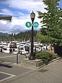
A lunch spot..and we are on the Trans Canada Trail


In the middle of the trail, actually.....
tctrail.ca/explore-the-trail/


Trans Canada Trail
From Wikipedia, the free encyclopedia
| Trans Canada Trail | |
|---|---|

Trans Canada Trail pavilion in Fredericton, New Brunswick.
|
|
| Established | 1992 |
| Length | (As of 2012) 16,800 kilometres (10,400 mi) |
| Location | Canada |
| Trailheads | St. John's, Newfoundland, Victoria, British Columbia, Tuktoyaktuk, Northwest Territories |
| Use | Hiking, biking, equestrianism, cross-country skiing, snowshoeing, all-terrain vehicles, canoeing |
| Elevation | |
| Lowest point | Sea level |
| Hiking details | |
| Trail difficulty | Variable |
| Season | All seasons |
| Sights | Numerous |
| Hazards | Multiple |
| Surface | Variable |
| Right of way | Multiple |
| Website | tctrail.ca |
The creation of the Trail was borne of Canada's 125th anniversary celebrations in 1992.[2] It has its counterparts in such other greenway routes as the 12 EuroVelo routes, the UK's National Cycle Network, and the USA's East Coast Greenway.
To date it has been funded largely by Canadian federal and provincial governments, with significant contributions from corporate and individual donors. The first province to have completed its designated section of the trail was Prince Edward Island (see Confederation Trail).
The network of the Trans Canada Trail is made up of more than 400 community trails. Each trail section is developed, owned and managed locally by trail groups, conservation authorities and by municipal, provincial and federal governments, for instance in parks such as Gatineau Park or along existing trails such as the Rideau Trail and Voyageur Hiking Trail. The Trans Canada Trail supports and is made up of greenways.[3]
Moreover, considerable parts of the Trail are repurposed defunct rail lines donated to provincial governments by CP and CN rail rebuilt as walking trails. As such, much of the Trans Canada Trail development emulated the successful Rails-to-Trails initiative in the United States, whereby these transportation corridors are "rail banked" as recreational trails, allowing conversion back to rail should future need arise.
Thousands of Canadians, community partner organizations, corporations, local businesses and all levels of government are involved in developing and maintaining these trails. The Trans Canada Trail does not own or operate any trail. As an ensemble, the Trans Canada Trail might be one of the largest volunteer projects ever undertaken in Canada.
The main section runs along the southern areas of Canada connecting most of Canada's major cities and most populous areas. There is also a long northern arm which runs through Alberta to Edmonton and then up through northern British Columbia to Yukon.[4]
The Trail is multi-use and depending on the section may allow hikers, bicyclists, horseback riders, cross country skiers and snowmobilers. In theory, the Trail is equipped with regularly spaced pavilions that provide shelter as well as fresh water to travellers, but this varies widely from section to section, and particularly from province to province.
"Mile Zero" of the Trail is located outside the Railway Coastal Museum in St. John's, Newfoundland.
Contents
Infrastructure
Newfoundland and Labrador
The Trail Eastern Terminus starts in Saint Johns where it is known as the Grand Concourse Trail it passes by Saint Johns Harbour travelling south crossing Route 2 into Kilbride then through Bowring Park. Continuing north-west through Mount Pearl then Donovans crossing Route 1 into Paradise passing Neils Pond then several others as it makes its way through Woodstock. The route then turns south-west passing through Chamberlains, Manuels, Talcville and Foxtrap where it crosses Route 60.The Trail continues through Conception Bay South where the trail is known as Newfoundland Trailway Park. Continuing south-west, the route passes through Riverdale and Hopewell, Indian Pond, Duffs then enters the east side of Holyrood Bay. The trail passes through Briens as it enters Hollyrood.
The route again crosses Route 60 then the North Arm River then travels north through Burnt Stump. The route travels south west passing Woodsford then passes through Brien's Gullies before then crossing Route 1 again. The route then passes through Brigus Junction, Mahers, then Ocean Pond then a mostly treed area before entering Whitbourne and crossing Route 80. Continuing the route crosses Route 100 then enters Placentia Junction before turning north passing over Coles Pond. Crossing Route 120, The next major location is Tickle Harbour Station where it again touches Route 1 and follows it crossing a few more times before entering Cobb's Pond then Come By Chance. The route continues as it enters Goobies, then Northern Blight, then crosses Route 1 as it enters Clarenville. The route follows Shool Harbour River as it enters Thorburn Lake then crosses Route 233 as it Port Blandford then crosses Route 1 again as it enters Terra Nova.
The Trail changes to Gambo to Terra Nova Trail as it Continues to Alexander Bay then route 1 then Route 320 as it enters Gambo.
Continuing north, the next leg of the trail is called Cobb Corridor Trail as it enters Butts then Benton then turning north-west as it enters Gander. As it continues, the route passes Glenwood then continues to Notre Dame Junction passing Route 340 and finally Norris Arm.
The next section is Newfoundland Trailway Park continuing to Rattling Brook, as it follows the Exploits River through Junipers Brook, Bishops Falls, Crossing Route 350 and continuing through Grand Falls.
Now known as Exploits Valley and Beothuk Trail the trail moves along into Windsor then Badger From here it is known as Newfoundland Trailway Park and travels through West Lake, Millertown Junction. the route passes through Quarry, Gaff Topsails, Kittys Brook, Howley where it crosses the Main Brook and ending in Deer Lake.
The next stretch is simply called Deer Lake to Corner Brook Trail and pretty much follows Route 1 through Pasadena, Steady Brook and Corner Brook on the south side of the Upper Humber River ending as it crosses Route 450.
continuing south, the route is now known as Newfoundland Trailway Park passing through Mount Moriah then continuing on Harrys River into Gallants then crossing Route 460 as it crosses Route 461 at Stephenville Crossing in St. George's Bay. Passing through St. George's, the route crosses Fischells Brook, then crosses Route 404 in Cartyville. Passing through St. Fintans, the route continues to Codroy Pond then South Branch, Benoits Siding, Doyles, Tompkins, St Andrews, and ending in Cape Ray.
The last stretch of the trail in Newfoundland is known as the Wreckhouse Trail. This trail passes through Osmond, Grand Bay, and ends in Port aux Basques where you would take the Port Aux Basques to North Sydney Ferry to North Sydney, Nova Scotia.
New Brunswick
Shogomoc River Pedestrian Bridge is a 265 foot suspension bridge in Canterbury, New Brunswick. Part of the Trans Canada Trail and the Sentier NB Trail network, it officially opened in October 2011 accompanied by a ribbon cutting ceremony with Valerie Pringle present as a Trans Canada Trail representative. Sentier NB Trail provided over $300,000 towards the project. It is known as the final non-motorized trail link between the town of Grand Bay–Westfield and the border of the province of Quebec.Ottawa/Kanata - The trail here is covered in small gravel and seems well maintained.
Photos
-
 Trans Canada Trail along Coal Harbour in downtown Vancouver, British Columbia
 -
 Trans Canada Trail in Grand Forks, British Columbia
 -
 Trans Canada Trail in Manitoba at Silver Springs Park viewed from Birds Hill, R.M. of East St. Paul
 -
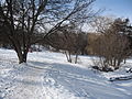 Trans Canada Trail in winter in Peterborough, Ontario
 -
 Trans Canada Trail marker in Tuktoyaktuk, Northwest Territories
 -
 The newly restored Kinsol Trestle, which spans the Koksilah River on Vancouver Island.


This is remnants of a suspended cable walking bridge.


No comments:
Post a Comment